
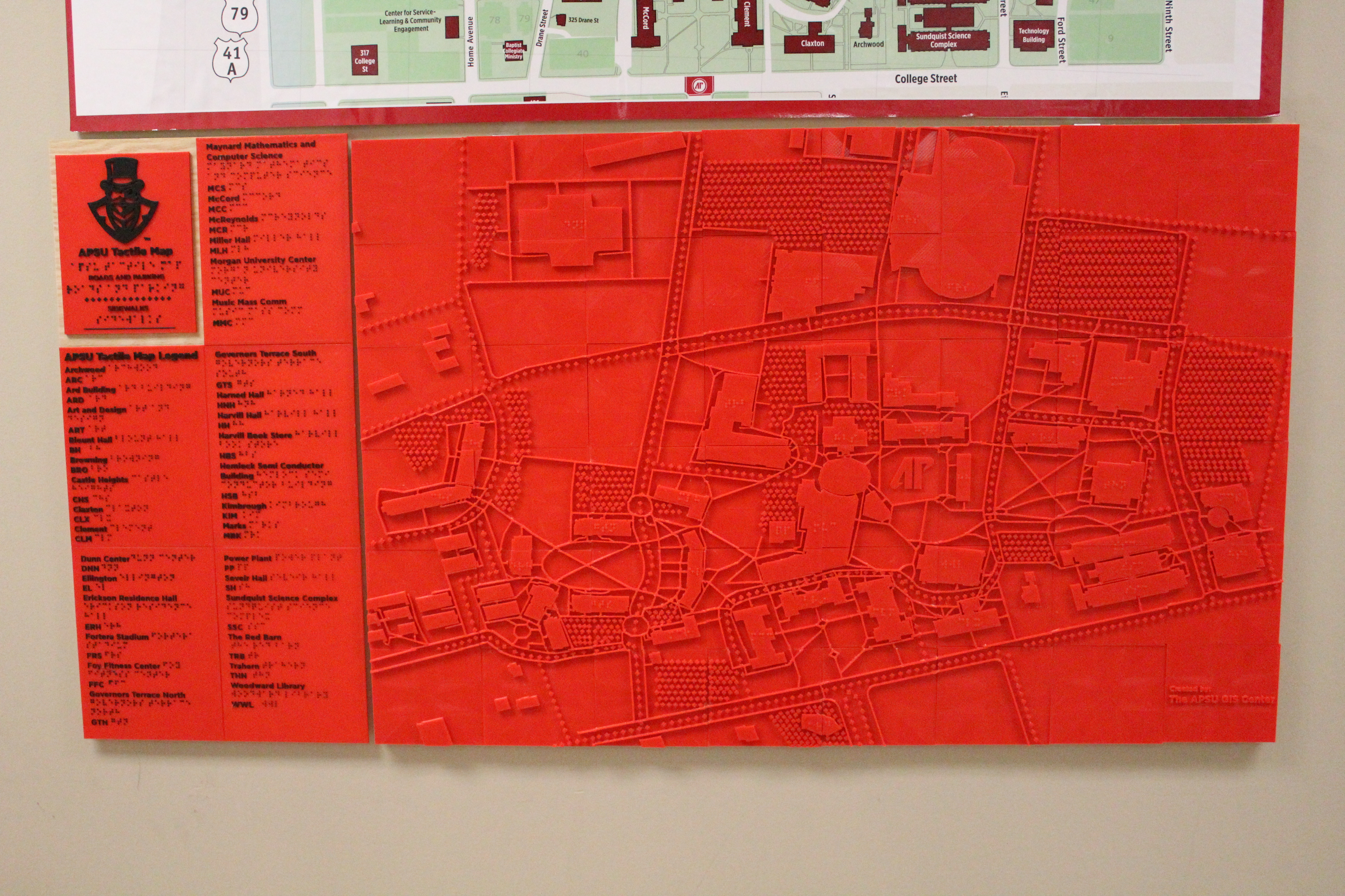
APSU’s Geographic Information System (GIS) Center has created a tactile map of campus for the visually impaired using 3D printing.
This project was a collaboration between the Office of Disability Services and the GIS Center. The Director of Disability Services Jaime McCreary reached out first asking GIS Director Michael Wilson to create a map for the visually impaired.
“Basically, what ended up happening was I came back to the office knowing we had a 3D printer. Mike Hunter is a Graphic Design student with us here who runs our 3D printers, and I said to him, ‘Hey, is this something you could put together?’” Wilson said. “He did some research on it and then basically started putting it together.”
From there, Hunter began the process of determining how to utilize their 3D printing technology to create a working tactile map.
“After I got the request, I started looking into equipment trying to see if there was a program out there that was directly made so we could do it,” Hunter said. “There was one, but our biggest issue was there was nothing to differentiate between the roadways and sidewalks.”
Facing these challenges, Hunter had to adjust and rework his entire plan.
“After about a week of failed attempts I ended up having to cut my large map down into 48 squares and from there build it from the ground up again,” Hunter said. “After learning and sizing everything up properly, especially with the braille, there had to be certain character height, I scaled the map up to a 24 by 36 inch, essentially poster, to be used for the wall.”
The project in total took about a month and a half according to Hunter.
“The map’s made out of 48 tiles. Each tile took between three to six hours to print on the 3D printer,” Wilson said.
Another university campus in Tennessee with Braille tactile maps in the University of Tennesse Chattanooga (UTC).
Bryon Kluesner the Adaptive Technology Coordinator at UTC and former Assistant Director for the Office of Disability Services at APSU from 2004-06, was responsible for the implementation of tactile maps at UTC in 2008.
Using an outside vendor, InTouch Graphics, the project, which involved creating multiple maps, took six months.
Over ten years later, Kluesner says the maps have positively impacted his campus in a significant way.
“I have noticed many students and visitors to campus use the map to determine the location of buildings on campus. I hear comments on how unique the maps are,” Kluesner said. “I have loaned the portable maps to incoming students who are blind so they can learn to navigate campus prior to the semester beginning.”
As their campus grows and changes, however, Kluesner notes that changes need to be made.
“We have had new buildings built on campus and some that have been demolished. Once construction slows down, I am going to propose an update to the maps,” Kluesner said.
As APSU moves forward, Wilson plans to expand this tactile map project.
“We are testing printing small versions of the map for individual students. So, that way students can have something in their backpacks,” Wilson said. “We are testing that now to see one what it would look like, and then we actually probably need to meet with one of the students and see if it’s actually usable.”
This project has also inspired Wilson to work with local city and county governments, with whom the GIS center already does most of their work, to make more tactile maps.
“We’re probably going to probably talk to several of the local governments to see if they are interested in doing such a map, like for the park systems, the walking trail, the greenway down by the river,” Wilson said. “We’ve talked about the possibility of doing a tactile map for that area, again for the visually impaired.”
These kinds of projects that significantly the community for good are of particular interest to Wilson.
“We try to do projects that have a positive impact on our community, and students that are interested in working on projects that have a positive impact please come see us,” Wilson said.